Environ - Technology Towards Nature

About Hydrodyn-OILSOFT

 
Hydrodyn-OILSOFT
About Hydrodyn-OILSOFT

It is an absolute user friendly system, developed specifically for environmental engineers, who may not have much exposure to numerical concepts in data creation , calculation and analysis.

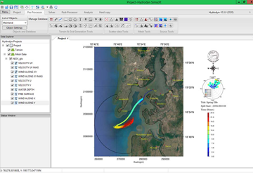
Hydrodyn-OILSOFT is an advanced software package, with a Graphical User Interface(GUI) consisting of pre-processor, multiple solvers and post processor that can simulate fate and movement of oil spills, in rivers, seas and coastal waters of estuarine systems in a complex geometry with high precision using higher order numerical schemes. OILSOFT provides rapid predictions of the movement of spilled oil in all meteorological and hydrological conditions. It includes user friendly graphical interface for entering both wind and hydrological data and specifying the spill source scenario. Hydrodyn-OILSOFT includes many specialized features of graphics and menu driven pre/postprocessor for setting up the input, running the calculation, and selecting and obtaining graphical output from the analysis, animation facilities, trajectory plots etc. It allows fast, flexible creation and modification of computational models to reduce the possibility of errors in the input.

Software Gallery
Features
  • Uses a Finite Element approach.
  • Built-in 2D/3D mesh Generator, which is based on Finite Element Method.
  • Interactive with GIS data management system.
  • It can display the oil spill trajectory at any time during the computation.
  • It is capable of handling various type of oils in the prediction of fate and trajectory of oil spills in open waters.
  • Integrated Spill Trajectory and Fates model, Stochastic model, Backtracking model, Subsurface Transport model for sub-sea releases and blowouts in the program.
  • Comprehensive oil characteristic database in built.
  • Spill scenarios can be specified.
  • Input winds time series feasible.
  • Capability to enter and edit oil types in the oil library.
  • Displays GIS resources affected by the oil trajectory.
  • The GIS utility is highly interactive and allows the user to enter, or import from external GIS sources, a variety of geographic data such as response resources, environmentally sensitive areas, and key coastal features.
  • It has animation facility for the output results of various file formats i.e. Bitmap, ASCII.
  • Dispersant effectiveness and over-flight update tools built-in.
 
Application Areas

Hydrodyn-OILSOFT covers the following model applications

  • Assessing the risks due to oil spills and impacts on marine life and ecosystem
  • Either as a real-time basis to predict the movement of oil spill or as a scenario model to analyze the possible impact of accidental oil spill.
  • It generates multiple stochastic simulations for selected spill locations using statistical or historical wind time series
  • It can be run to determine most likely spill paths for spills on a monthly, seasonal, or annual basis.
  • Output includes maps showing probabilities of oiling the water surface and shorelines in the vicinity of the spill site, and contours of oil travel time.
  • The software output results can be used to determine the probability of oiling static resources which are stored in the GIS.
  • The software can be used to perform reverse trajectory calculations for selected sites.
  • Calculations can be used to identify probable release locations of spills given current oil locations, or principal avenues of vulnerability for important resources.
  • Outputs of the receptor mode are maps showing probabilities that the spill trajectory passed through a given area, and minimum time contours for spills to reach resources of concern.
  • Predicting the weathering and transport of spilled oil in surface and subsurface.
  • Predicting the probability areas of oil reach and their impact.
  • Risk assessments due to accidental or continuous oil spills and due to operational discharges/leakages.
  • Search and rescue operations.
  • Tidal Circulation and Oil spill transport.
  • Oil spill Trajectory analysis.
  • Analysis of various physical and chemical properties of oil spill in the offshore for EIA studies.
  • Predict the probability of key areas being affected a given site (stochastic).
  • Predict the backtracking the model to determine the likely spill location (receptor).
  • Allow over-flight update predictions.
  • Predict boom-oil interaction.
  • Provides first order guidelines in the use of dispersant and help develop dispersion strategies around coastline.
  • Performs risk assessments for important resources e.g. beaches, fisheries, marine life, protected coastlines and industrial water intakes etc.
  • Helps in review and update both national and regional emergency contingency plans.
  • Helps to develop coastal planning and management data bases using interactive GIS.
  • Helps to prepare and carry out both regional and national oil spill training exercises.
  • Provides management with a user-friendly tool for decision support and effective visual communication in the event of an emergency spill incident.
  • Useful for Impact and risk assessment.
  • Useful for developing Oil spill response and contingency planning.
  • Resource management.
  • Environmental impact assessments.
  • Protection and prevention strategies.
  • Environmental Audits.
  • Training courses.
  • Equipment review and recommendations.
  • Equipment commissioning.
  • Exercise delivery.
  • Oil & chemical spill facility design.
  • Emergency response and spill management services.
  • To determine the vulnerability of a particular site to oil spills based on tanker traffic routes.
  • To determine possible sources of oil when oil has been observed at a particular site.
  • Optional capability to customize a resource and cost management system.
Software Capablities
  • This software is flexible and can be used for any geographical locations in the world.
  • It can be used to simulate slick trajectories in tidal and non-tidal flow domains.
  • The model can be used for either continuous or instantaneous oil spills and the model takes into consideration various processes including advection, mechanical spreading, horizontal turbulent diffusion, evaporation, dissolution and shoreline deposition.
  • It allows fast, flexible creation and modification of computational models, while greatly reducing the possibility of errors in the input.
  • It can be used either as a real-time basis to predict the movement of oil spill or as a scenario model to analyze the possible impact of accidental oil spill.
Download Brochure
Please Fill the details to download Brochure